Can We Use BeiDou in NZ? A Practical Guide for Developers and Innovators

*a detailed breakdown of the BeiDou Navigation Satellite System (BDS), how it works, where it stands now, and whether “we” (civil users, globally, or in NZ) can use it:
BeiDou Navigation Satellite System
What is BeiDou
BeiDou (北斗, “Northern Dipper”) is China’s global navigation satellite system (GNSS), analogous to the U.S. GPS, Russia’s GLONASS, Europe’s Galileo, etc.
It provides Positioning, Navigation, and Timing (PNT) services globally.
The system development is typically divided into three phases:
1. BeiDou‑1 (experimental/regional)
2. BeiDou‑2 / “Compass” (regional Asia–Pacific)
3. BeiDou‑3 (global coverage)
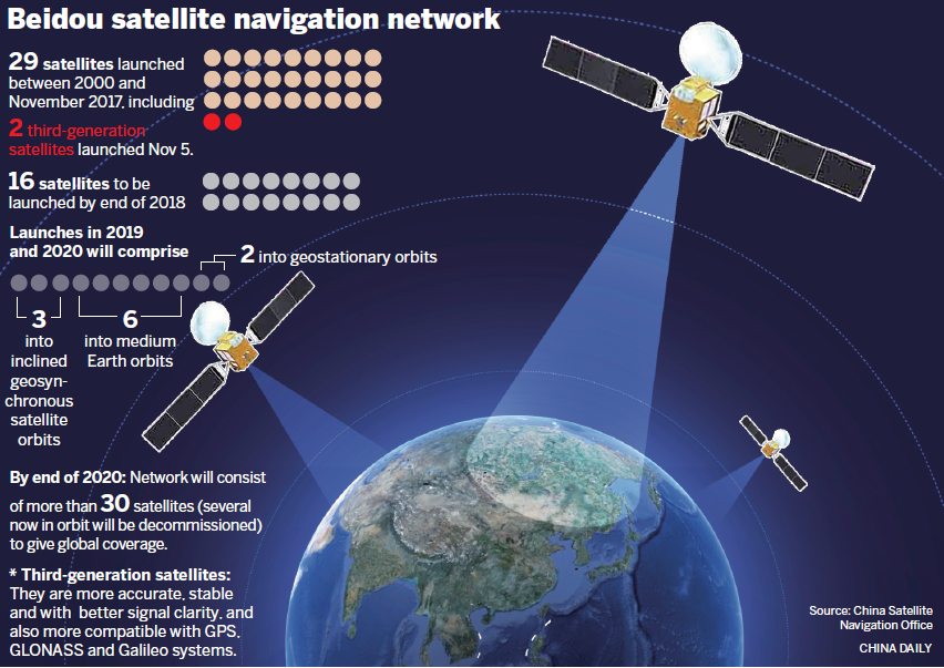
BeiDou‑3 became fully operational around 2020, meaning the constellation now offers global service.
The constellation architecture includes satellites in multiple orbital regimes: medium earth orbit (MEO), inclined geosynchronous orbit (IGSO), and geostationary orbit (GEO).
BeiDou also supports additional features like short messaging (for two‑way messaging), which is a distinctive capability relative to many GNSS systems.
Performance & Accuracy
As a public/open service, BeiDou aims to deliver metre-level accuracy globally; in the Asia‑Pacific region its accuracy is better (a few metres).
For higher precision, BeiDou has “PPP” (Precise Point Positioning) modes: for example, the PPP‑B2b service of BDS‑3 can achieve decimetre (10s of cm) accuracy in certain conditions (after convergence)
The system uses advanced time and clock synchronisation techniques (including inter‑satellite links) to maintain high precision.
Use & Availability: Can we use BeiDou?
The short answer: Yes, in most cases modern GNSS receivers can make use of BeiDou signals, and civil users globally can benefit from it including in New Zealand as long as their device supports it.
Here are more detailed caveats and practical aspects:
Device Support
A navigation or positioning device (receiver) must have hardware/firmware support for BeiDou (i.e. it must listen to BeiDou satellite signals / frequencies). Many modern multi‑GNSS chips support GPS + GLONASS + Galileo + BeiDou.
For example, many smartphones now include BeiDou in their GNSS stack (depending on manufacturer).
If your device is older or only supports GPS (or only certain GNSS), it may not be able to use BeiDou signals.
Signal Visibility & Geometry
Having more satellites from multiple systems improves availability, redundancy, and accuracy (especially in obstructed environments like urban canyons). BeiDou acts as an additional constellation to boost the performance when combined with other GNSS.
In New Zealand (or anywhere outside the Asia‑Pacific “home region” for BeiDou), the signal strength, number of visible BeiDou satellites, or geometry might be less optimal compared to in its home region. But that doesn’t preclude use - it just means BeiDou’s contribution is supplementary.
Access & Restrictions
BeiDou offers both open (public) services and restricted (military/authorized) services. Civil users are generally limited to the open signals.
There is some concern/criticism in policy/law/security circles about the messaging/tracking potential of BeiDou’s two‑way signalling features. Some analysts warn that BeiDou’s communication features could conceivably allow location broadcasting or control messages in some contexts.
As of now, there is no public indication that civil users outside China are blocked from using BeiDou’s open services. Many countries already include BeiDou integration in their GNSS standards and devices.
Some reports mention that over 120 countries/regions are using BeiDou‑3.
Practical in NZ
If you have a modern GNSS receiver (e.g. RTK / surveying gear, high-end multiconstellation GNSS chipsets), chances are it already supports BeiDou, or can be configured to do so.
For consumer devices (phones, handheld GPS units), check the specs: e.g. “GPS + BeiDou + Galileo support” or “multi-constellation GNSS”.
The accuracy gain you’ll see from BeiDou will depend on how many BeiDou satellites are visible from your location, and whether the device combines them well with signals from GPS / Galileo / GLONASS.
China Daily
Useful Official / Technical Links & References
Here are some authoritative or technically detailed sources you might explore:
BeiDou official site / system overview
“System – BeiDou” (English) — overview of the system.
Interface Control Documents / Technical Specs
“BeiDou Navigation Satellite System Signal In Space Interface” (PDF) — technical specifications.
Navipedia – BeiDou General Introduction
Good general technical & systems view.
UNOOSA – Development of BeiDou Navigation Satellite System (2024)
Up‑to‑date slide / report on system development.
GPS World — “BeiDou Navigation Satellite System in 2024”
Current developments and status.
Research article — High‑precision services of BeiDou navigation satellite system (BDS)
On the accuracy, constraints, and high‑precision modes.
Belfer Center — “China’s BeiDou: New Dimensions of Great Power Competition”
Good for geopolitical / strategic context.
GPS World — “BeiDou a threat to the West, but perhaps not individuals”
Perspective on security / policy concerns.
What NZ / local research says about BeiDou + GNSS in NZ
The University of Otago has a project on low-cost GNSS + BeiDou RTK (using GPS L1 + BDS B1) in New Zealand (Dunedin) to see how well it works in practice. They found that combining BeiDou with GPS increases the number of satellites and makes single‑frequency RTK more viable.
Because more satellites = better geometry and redundancy, multi‑GNSS (GPS + BeiDou + Galileo + GLONASS) generally improves accuracy, robustness especially under challenging environments (signal obstructions, multipath).
In NZ mapping / surveying contexts, differential GNSS / RTK / network RTK are used, typically yielding ~1–3 m with basic differential GNSS, and centimetre‑level with RTK + corrections.
In more challenging terrain (urban canyons, vegetation, multipath), accuracy degrades unless you use mitigation algorithms, quality antennas, and good receiver design. (Multipath is a big concern for GNSS)
So the upshot: yes, in NZ, using BeiDou in combination with GPS and other constellations does bring value, especially for high-accuracy applications with the right hardware.
In Wellington specifically, expect similar constraints — good sky view helps a lot. In obstructed views (between buildings, under trees), performance will degrade more severely.
What to look for in hardware / receivers
If you want to test or deploy your own systems (surveying, robotics, etc.), these are the key specs / features to check:
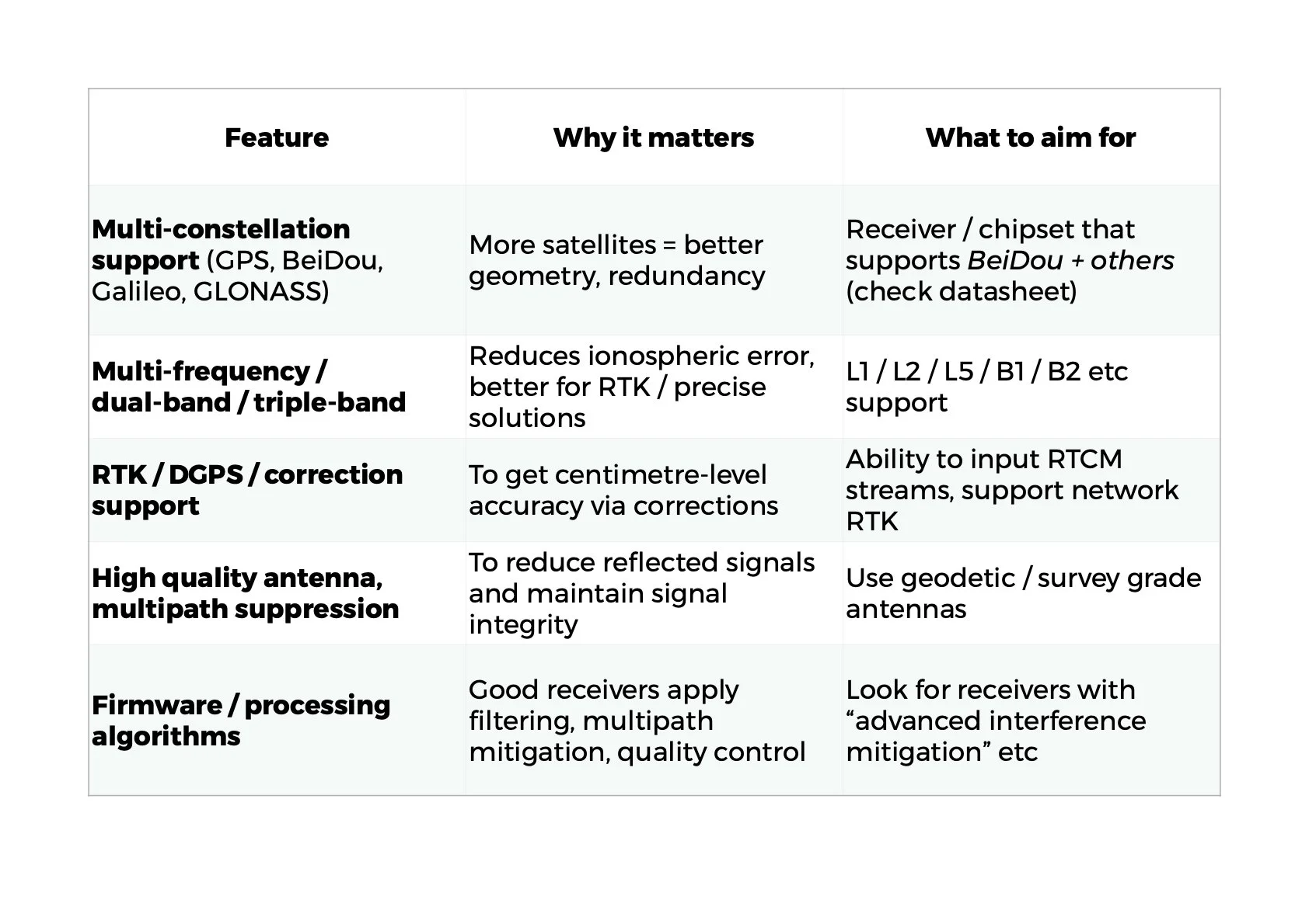
Also check in the module datasheet whether BeiDou signals are supported (which BeiDou bands: B1, B2, etc).
Example hardware / receivers you could try
Here are some receivers / modules you might order or test:
Here are a few highlights:
Emlid Reach RS3 Multi‑band RTK GNSS Receiver — high end, multi-band, good for serious surveying / field testing.
Emlid Reach RX Lightweight RTK GNSS Receiver — lighter, more compact, good for mobile / UAV / field use.
Emlid Reach M+ GNSS Receiver — more of a “GNSS / mapping grade” than full RTK, but useful for testing multi‑constellation effects.
CHCNAV GNSS Surveying Package — full kit for surveying, typically with base + rover.
ByNav C2‑M21‑U RTK GNSS Receiver with IMU — includes IMU which helps in path continuity when GNSS signal is temporarily lost.
GNSS 23 Click Module — small module board, good for prototyping / experimentation (less robust in field, but useful for development).
Before buying, inspect their datasheets to confirm BeiDou (which bands) support, and whether they support RTK corrections (RTCM, NTRIP, etc).
Also, smaller / lower cost modules often support single frequency only (e.g. L1 / B1) which limits performance in challenging conditions. But combining more constellations even on single frequency is beneficial (as the Otago NZ work suggests).
Additionally, many GNSS IC / module suppliers (e.g. ST’s Teseo series) support quad‑band and multiple constellations including BeiDou.
What performance you might realistically get in Wellington
Given sky conditions, obstructions, and NZ’s use of corrections:
With a good multi‑constellation / multi‑frequency RTK setup and good corrections (network RTK / base station), you could expect cm‑level horizontal accuracy under open sky conditions.
In more constrained environments (urban, trees, partial sky), the accuracy might degrade to decimetres or worse, depending on signal blockage / multipath.
Using simpler differential GNSS (non‑RTK) you might get 1–3 m typical accuracy in many NZ settings.
The added benefit of using BeiDou is mostly better satellite availability (thus fewer “dropouts”, better geometry), particularly under partial sky or where GPS alone has fewer visible satellites.