
*powered by iSPARX™

AR+EVP
The next evolution of our platform, developed as part of Calgary's 5G Discovery Zone Network API Challenge: The iSPARX™ AR+ Environmental Visualization Platform. We're leveraging our expertise in immersive technology to tackle one of the most pressing issues of our time – understanding and responding to environmental change.
What is the iSPARX™ AR+ Environmental Visualization Platform AR+EVP)?
The iSPARX™ AR+ Environmental Visualization Platform (AR+EVP) is an advanced immersive technology solution designed to make environmental data more accessible, understandable, and engaging through augmented reality (AR). It is a core component of the AR+IQ™ suite developed by iSPARX™ Innovation Inc., targeting environmental awareness, climate adaptation, and community engagement.
Key Features and Capabilities
Augmented Reality Integration: Utilises location-based AR to overlay real-time and historical environmental data on physical spaces, turning them into interactive storytelling environments.
Network API Utilisation: Leverages Rogers 5G and CAMARA APIs such as:
Connected Network Type
Geofencing Subscriptions
Location Retrieval
Simple Edge Discovery
Quality on Demand
Connectivity Insights
These enhance performance, precision, and responsiveness by dynamically adapting content quality and delivery based on network conditions.
Ethical and Cultural Design: Built on Indigenous data sovereignty principles and co-developed with Indigenous knowledge holders, ensuring cultural inclusivity and ethical storytelling.
Use Cases:
Environmental Monitoring – Visualise air quality, water levels, and climate trends using Calgary’s open data.
Urban Planning – Aid decision-making with spatial overlays for development projects.
Education – Provide immersive place-based learning experiences.
Public Engagement – Enable citizen science and participatory mapping.
Technology Stack:
Built on Microsoft Azure with microservices architecture.
Uses Unity, ARCore/ARKit, and Google Geospatial Creator.
Custom CMS for Indigenous-led content curation.
Compatible with mobile devices and wearables.
Strategic Alignment
This platform aligns with:
Calgary’s Smart City Strategy: Enhancing public access to data and promoting sustainable, tech-savvy urban growth.
UN Sustainable Development Goals (SDGs): Specifically supports SDGs related to sustainable cities (Goal 11), climate action (Goal 13), and quality education (Goal 4).
Benefits
For Public: Enhances environmental literacy and civic participation.
For Government and Planners: Offers a real-time, visual decision-making tool.
For Researchers: Enables immersive field data interaction.
For Educators: Facilitates dynamic, place-based curriculum content.


*powered by iSPARX™


flood plane - with visualization
air quality
transport directions
transport parking
parks (recreational not transport) with descriptions
map of public art
map of history

CASE STUDY
9th Avenue & 4th Street underpass across from Studio Bell in the East Village.
coordinates 51.044331346556056, -114.05329978552795


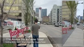
CASE STUDY
17th Ave & Centre Street looking toward the Calgary Tower
51.044331346556056, -114.05329978552795

